
File:Gz-map.png
No higher resolution available.
Gz-map.png (330 × 354 pixels, file size: 13 KB, MIME type: image/png)
Summary
| Description |
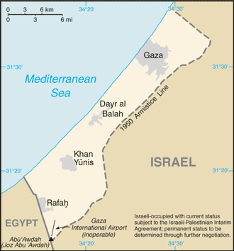
English: A map of the Gaza Strip showing key towns and neighbouring countries. |
|||
| Source | Gaza Strip from CIA factbook | |||
| Author | CIA | |||
| Other versions |
[] Ver1:
Ver2:
|


Licensing
This image is in the public domain because it contains materials that originally came from the United States Central Intelligence Agency's World Factbook.
|
 |
File history
Click on a date/time to view the file as it appeared at that time.
| Date/Time | Thumbnail | Dimensions | User | Comment | |
|---|---|---|---|---|---|
| current | 06:24, 12 December 2008 | | 330 × 354 (13 KB) | commonswiki>Mattflaschen | Put back latest image from Factbook. This includes the note (don't know whether it was there on December 2, 2007). |
File usage
The following page uses this file: